Walking & cycling
Trail Map
13 miles of trail wrap right around the reservoir. Pick a route on the map to see where it goes, who it suits and what you will pass along the way.
Tap a route to bring it to life. Drag to move around the map, pinch or use the buttons to zoom, and use the arrows button to open the map full page. Hold Ctrl and scroll to zoom with a mouse.
Choose a route
Map key
The colours and symbols match the route map boards and waymarker posts you will find around the reservoir.
- Suitable for more experienced and confident riders
- Suitable for children and less experienced riders
- Walking path only
- Hilly path not suitable for wheelchairs
- A to N waymarkers
- Mile markers
- Information points
- Toilets
- Viewing points
- Vineyards
Where the trails start
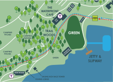
Every route sets off from the visitor centre, by the Waterfront Café. Both directions are signed from waymarker A.
Before you set off
On-site emergency number
Save this before a longer route. The waymarker letters and mile markers help us find you quickly.
07767 375115Check the season
Some sections may close from November until April when ground conditions are wet, so it is worth checking before a longer route. The trail is road stone and loose gravel, with natural ground in places.
Take a map with you
Printed trail maps are available from the Waterfront Café, and there are map boards at the information points around the reservoir.
Download the route map (PDF)